OpenAI 多个重磅炸弹公布:ChatGPT 里直接装 App

Cursor 创始人:AI 编程处于漫长复杂的「中间阶段」

华为工程人员回应「鸿蒙 5 App 不适配」:有些群体别升级
简配版 Model Y/3 正式发布
昨天,特斯拉正式在北美市场发布了旗下 Model Y/3 全新车型 ——「Standard」(标准版),先看售价:
- Model Y Standard 价格为 39990 美元(约合人民币 28.4 万元)
- Model 3 Standard 价格为 36990 美元(约合人民币 26.3 万元)
随着标准版的出现,特斯拉对车辆的命名体系也做了调整,在入门标准版之上是 Premium (臻享) 版本,即原来的 Long Range(长续航版),再往上则是 Performance(性能版)。
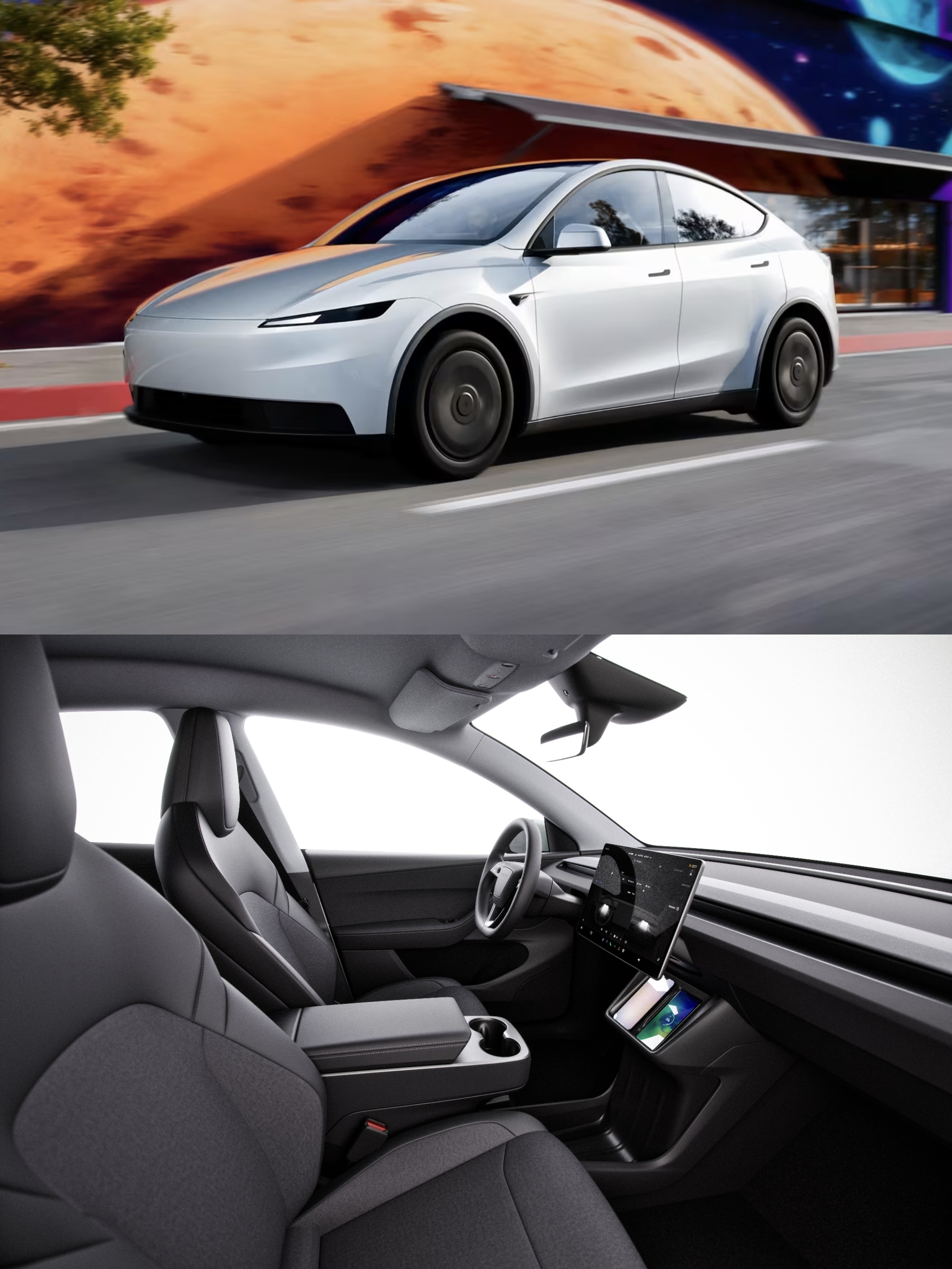
外观方面,Model 3 标准版并未进行大幅度调整;Model Y 标准版则取消了标志的贯穿式灯带。标准版车型提供 18/19 寸轮毂,车身颜色则仅有黑白灰三种颜色可选。另外,后视镜变为手动折叠。
内饰方面,标准版车型座椅材质更换为了织物材质,保留前排座椅加热,取消通风;方向盘调节更换为手动;后排触摸控制屏取消,变为手动空调出风口;扬声器均为 7 个(取消低音炮);移除 HEPA 过滤器和生物武器防御模式。
值得一提的是,Model Y 标准版取消掉了玻璃天幕以及电动后排座椅折叠;而 Model 3 标准版则保留了原来的天幕设计。
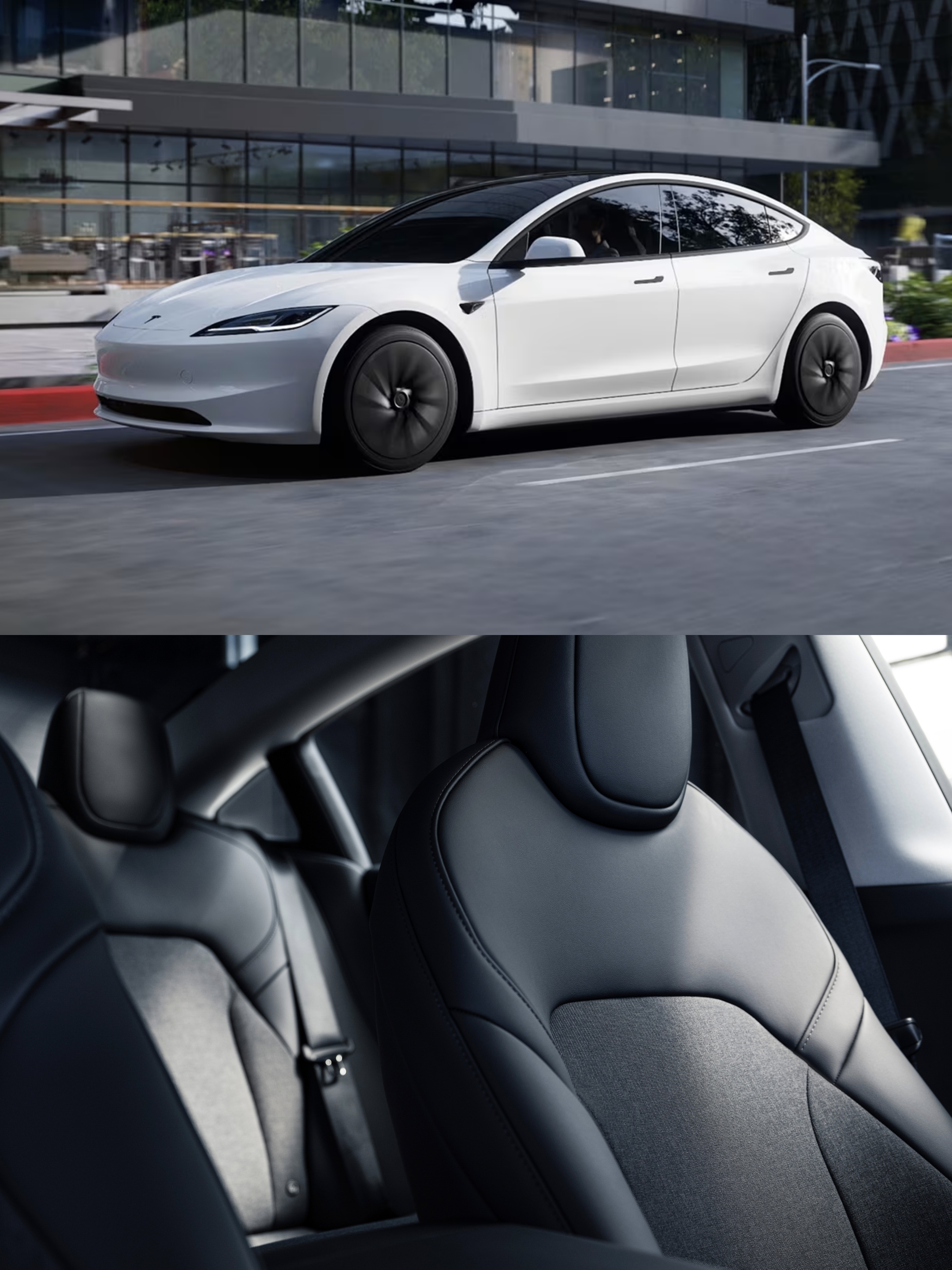
性能方面,标准版车型均为后驱电机,零百加速分别为 6.8 秒(Model Y)和 5.8 秒(Model 3);标准版电池采用 69.5kWh,续航里程为 516 公里,充电峰值功率被控制在 225kW。
相较原版本,两款新车分别降价约 5000 美元和 5500 美元。若按比例推算,其在中国市场的起售价可能分别下探至 23 万元与 20 万元左右。
2025 年诺贝尔化学奖公布
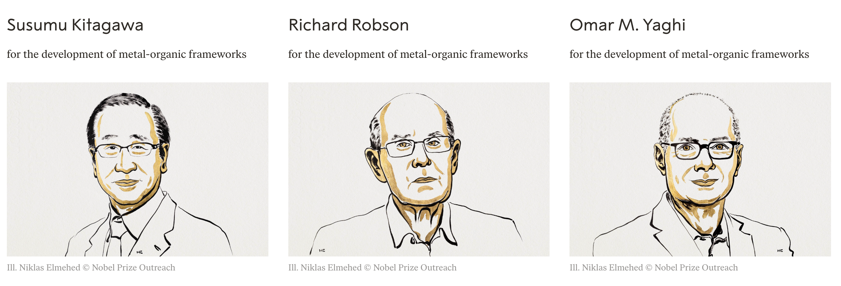
10 月 8 日,瑞典皇家科学院宣布,将 2025 年诺贝尔化学奖授予 Susumu Kitagawa、Richard Robson 和 Omar M. Yaghi,以表彰他们在金属有机框架(Metal–Organic Frameworks,简称 MOF)领域的开创性贡献。
三位获奖者将平分 1100 万瑞典克朗(折合人民币 836 万元)奖金。
据了解,三名获奖者创造的金属有机框架(MOF)内部拥有巨大的空腔,分子可以自由进出。研究人员利用它从沙漠空气中提取水分,从水中去除污染物,捕获二氧化碳并储存氢气。
过去几十年里,全球各地的实验室研发出无数类似的结构。有的被设计用于捕捉二氧化碳,有的用于从水中分离全氟和多氟烷基物质(PFAS),还有的能在体内精准递送药物,或安全处理极度有毒的气体。有的 MOF 甚至可以吸附水果释放的乙烯气体,让它们更慢成熟;也有的能包裹分解环境中抗生素残留的酶。
简单来说,金属有机框架的用途极其广泛。Susumu Kitagawa、Richard Robson 和 Omar Yaghi 之所以荣获 2025 年诺贝尔化学奖,是因为他们首次创造出 MOF,并展示了其巨大的潜力。
正是由于三位获奖者的工作,化学家们才能设计出成千上万种不同的 MOF,推动了化学领域一个又一个奇迹的诞生。
诺贝尔化学委员会主席 Heiner Linke 表示:「金属有机框架具有巨大潜力,它为定制化功能材料带来了前所未有的可能性。」
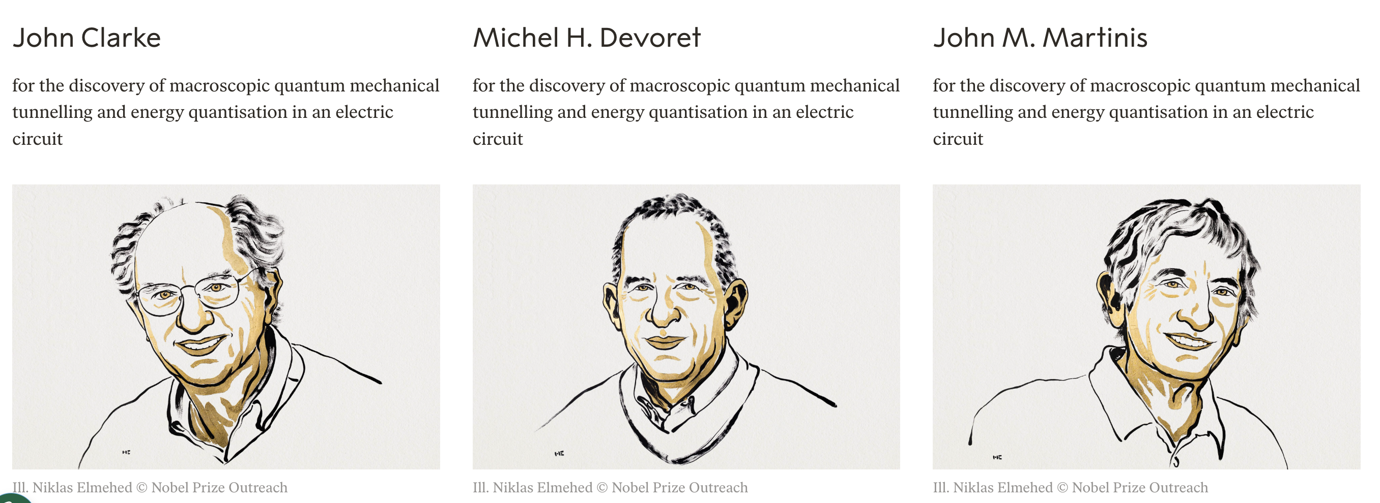
另外,瑞典皇家科学院在 10 月 7 日宣布,将 2025 年诺贝尔物理学奖授予 John Clarke、Michel H. Devoret 和 John M. Martinis 三名量子物理学家,以表彰他们在电路中实现宏观量子力学隧穿效应和能量量子化方面的贡献。
诺贝尔物理学委员会当天表示,今年的诺贝尔物理学奖成果为开发量子密码学、量子计算机和量子传感器等下一代量子技术提供了可能。
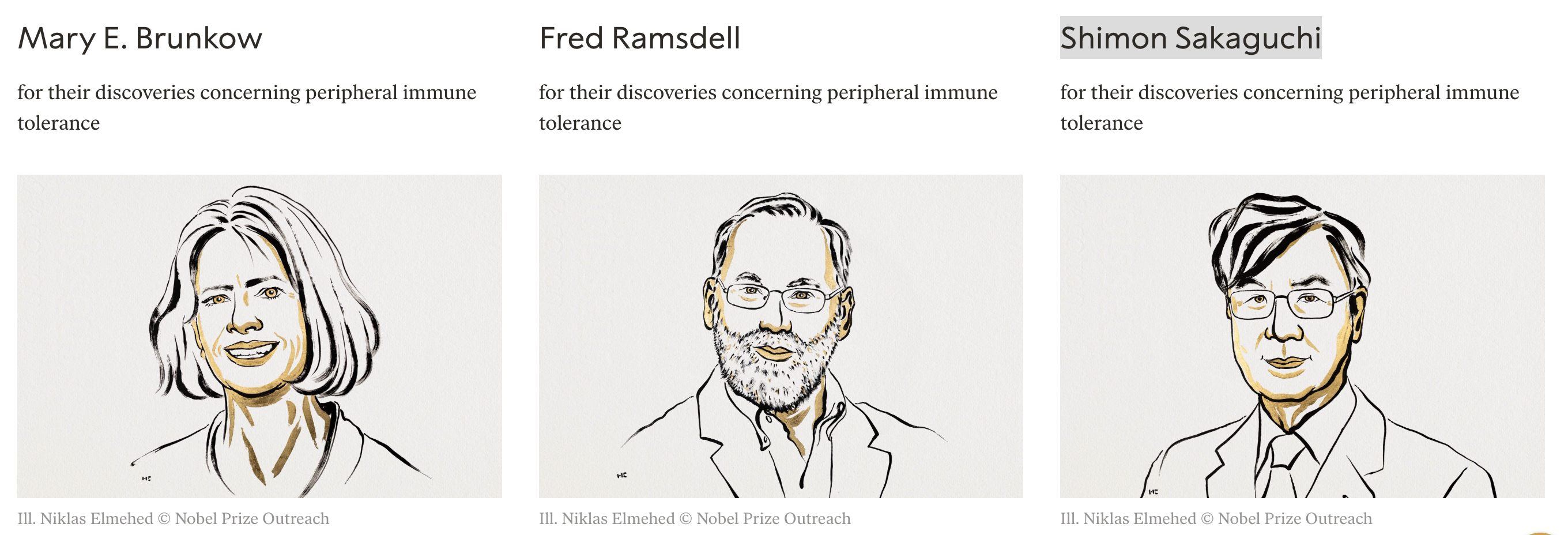
10 月 6 日,瑞典卡罗琳医学院宣布,将 2025 年诺贝尔生理学或医学奖授予美国科学家 Mary E. Brunkow、Fred Ramsdell 和日本科学家 Shimon Sakaguchi,以表彰他们在外周免疫耐受机制方面的开创性发现。
雷军:小米 17 系列首销成绩远超预期

日前,小米创办人雷军发文表示,小米 17 系列首销成绩远超预期。
据央视新闻报道,小米 17 系列凭借独特的「妙享背屏」创新、影像能力等,成为消费者新宠,开售仅 5 天销量破 100 万台。
另据博主数码闲聊站消息,小米 17 系列实际销售的激活量已破 70 万,同比强于前几代,全系线下销量是线上的 2-3 倍。
小米 17 系列于 9 月 25 日正式发布,共有小米 17、17 Pro 以及 17 Pro Max 三款机型,其中两款 Pro 机型拥有后置背屏设计;全系配备大容量电池、全新的徕卡影像系统;起售价分别为 4499 元、4999 元以及 5999 元。
小米 17 系列开售后,小米宣布新机全系开售 5 分钟,刷新 2025 年国产手机全价位段新机系列,首销全天销量、销额纪录。
据小米集团合伙人、总裁卢伟冰透露,三款新机中,小米 17 Pro Max 卖得最好,在全系中销量占比超过 50%。卢伟冰表示,「这说明小米靠持续创新上探超高端,赢得了大家的认可。」
据界面新闻报道,在发布会后的年度演讲及媒体采访中,小米创办人雷军表示,小米 17 系列全面对标 iPhone 17 系列,产品力在电池、屏幕、散热等方面已实现跨代升级。
他强调:「这是我们敢改名小米 17,敢正面对垒的底气和勇气。」
OpenAI 多个重磅炸弹公布:ChatGPT 里直接装 App
日前,OpenAI 在 DevDay 上公布了多项重点项目:
- ChatGPT 变超级 App:对话中直接调用第三方应用,AI 主动推荐工具,支持应用内交易变现。
- AgentKit 工具包上线:可视化拖拽搭建多 Agent 工作流,几分钟完成从开发到部署的全流程。
- Codex 全面开放:自然语言实时写代码,支持语音控制和 Slack 集成,自动审核 PR 提升团队效率 70%。
- 模型 API 大升级:最强 GPT-5 Pro 开放 API、语音成本降 70%、Sora 2 支持产品内视频生成和精细控制。
其中,ChatGPT 支持直接调用第三方应用后,用户只需一句话,Spotify、Canva 等应用就能在对话中自动唤起,还能提供可直接操作的交互界面。如果已经订阅了某个外部服务,还能在 ChatGPT 里直接登录账户,无缝衔接。
据悉,支撑上述技术的背后,是 OpenAI 全新发布的 Apps SDK(应用开发套件)。开发者现在可以使用 Apps SDK 预览版开始构建自己的 ChatGPT 应用。
值得一提的是,Apps SDK 构建在 Model Context Protocol(MCP)之上——这是个开放协议,允许开发者把外部数据源连接到 AI 系统,同时也意味着用这个标准构建的应用能在任何兼容平台上跑。
另据金融时报报道,OpenAI 今年签署了达 1 万亿美元的算力合作协议,并用于运行其人工智能模型。
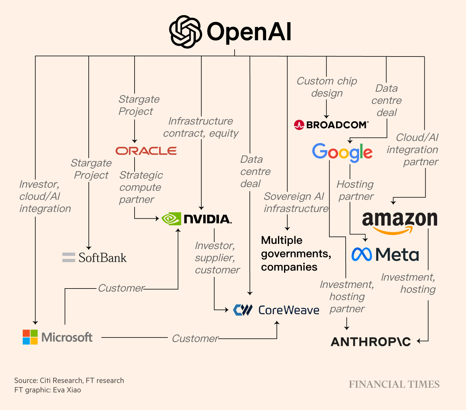
目前,已与 OpenAI 达成算力合作的已有英伟达、AMD、甲骨文、CoreWeave。
而这些合作将会为 OpenAI 在未来十年内,提供超过 20 吉瓦的计算算力,值得一提的是,这些算力所需的电力将约等于 20 个核反应堆所产。
而路透社最新报道显示,OpenAI 目前估值已经达到 5000 亿美元。据《The Information》此前报道,OpenAI 在 2025 年上半年创造了约 43 亿美元的收入,比去年全年增长了约 16%。
中国科研团队突破全固态电池实用瓶颈
据科技日报报道,全固态金属锂电池界面接触研究日前迎来重要进展。
报道称,中国科学院物理研究所/北京凝聚态物理国家研究中心黄学杰研究员团队,联合华中科技大学张恒教授团队、中国科学院宁波材料技术与工程研究所姚霞银研究员团队,开发出一种阴离子调控技术,能够在电极和电解质之间形成一层全新的界面。
具体来看,本次研究解决了全固态金属锂电池的一个棘手难题:固态电解质和金属锂电极之间必须保持紧密接触,传统做法要靠笨重的外部设备持续施压,导致电池又大又重,难以投入实际应用。
为了解决这一难题,研究团队开发出一种新技术:他们在硫化物电解质中引入了碘离子。这层界面能够主动吸引锂离子,像「自我修复」一样自动填充进所有的缝隙和孔洞,从而让电极和电解质始终保持紧密贴合。
更重要的是,基于该技术制备出的原型电池,在标准测试条件下循环充放电数百次后,性能依然稳定优异,远远超过现有同类电池的水平。
研究人员表示,这种新设计的优势非常明显:它不仅制造更简单、用料更省,还能让电池更耐用。他们特别强调,采用这项技术未来可以做出能量密度超过 500 瓦时/千克 的电池,这样一来,电子设备的续航时间有望提升两倍以上。
相关研究成果 10 月 7 日发表于《自然·可持续发展》杂志以及《先进材料》杂志。
马斯克晒擎天柱机器人练功夫
近期,马斯克晒出一段特斯拉 Optimus(擎天柱)人形机器人模仿人类动作打功夫的视频。
视频中展示的为 Optimus 二代机器人,其几乎一比一还原了演示人员的动作姿态,并且全程延迟较低,动作较为连贯流畅。
值得一提的是,马斯克在评论区表示,这并非遥控操作,而是通过 AI 学习完成了本次「练功夫」。
另外,英伟达 CEO 黄仁勋日前在接受 CNBC 报道时透露,自己对马斯克旗下的 xAI 融资机会感到十分兴奋,甚至抱有遗憾 —— 没给 xAI 投入更多钱。
黄仁勋表示,基本上每一件马斯克参与的事情,自己都想切身加入进去。其还表示,这并不是一次供应商融资。
据彭博社报道,英伟达将在 xAI 的股权部分投资高达 20 亿美元。报道还表示,包括股权和债务的融资将与 xAI 计划在其数据中心 Colossus 2 中使用的英伟达图形处理单元挂钩。
据悉,xAI 本轮融资将提高至 200 亿美元。
清华物理天才姚顺宇官宣跳槽 DeepMind
昨日,姚顺宇(Yao Shunyu)在个人博客官宣从 Anthropic 跳槽到了 Google DeepMind。
需要说明的是,如今在大模型领域,叫 Yao Shunyu 的大名鼎鼎研究者其实有两位。本次主角 —— 姚顺宇本科毕业于清华,研究兴趣横跨理论凝聚态、量子混沌与高能物理。
至于另一位 Yao Shunyu(姚顺雨)的故事,可以翻看我们此前的报道:腾讯辟谣 OpenAI 姚顺雨 1 亿薪资入职,27 岁清华姚班天才已开启下半场。
2024 年 10 月,姚顺宇正式加入 Anthropic Claude 团队,开始搞大模型研究。结果干了不到一年,就官宣跳槽了。而截至 2025 年,其论文总引用次数达到 5020 次(其中 2020 年后积累了 4678 次),h 指数为 14。
虽然姚顺宇认为 Anthropic 是物理学家进入 AI 研究的最佳起点之一,但他还是在 9 月 19 日从 Anthropic 正式离职,9 月 29 日加入 Google DeepMind。他在博客里给出了两个原因:
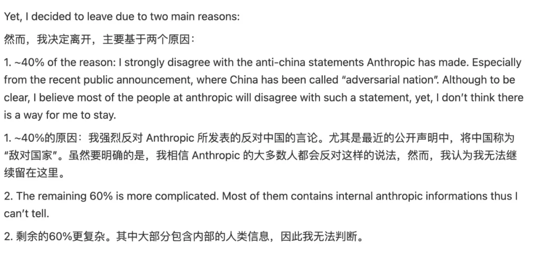
在昨日公开的博客信里,姚顺宇还坦诚地阐述了转向 AI 的初衷。理论物理虽然思想深邃,需要数学、计算机科学和物理的广博知识,但这个领域多年来几乎没有新的实验突破。一个缺乏实验的学科,很难客观判断研究的重要性,也很难通过系统化实验来化解分歧。
所以他最终在 AI 和量子计算之间选了前者。虽然量子计算未来会很重要,但目前瓶颈主要在实验平台上。相比之下,AI 更吸引他,因为和物理研究有某种相似之处。
大疆宣布降价,已购消费者退货维权登上热搜
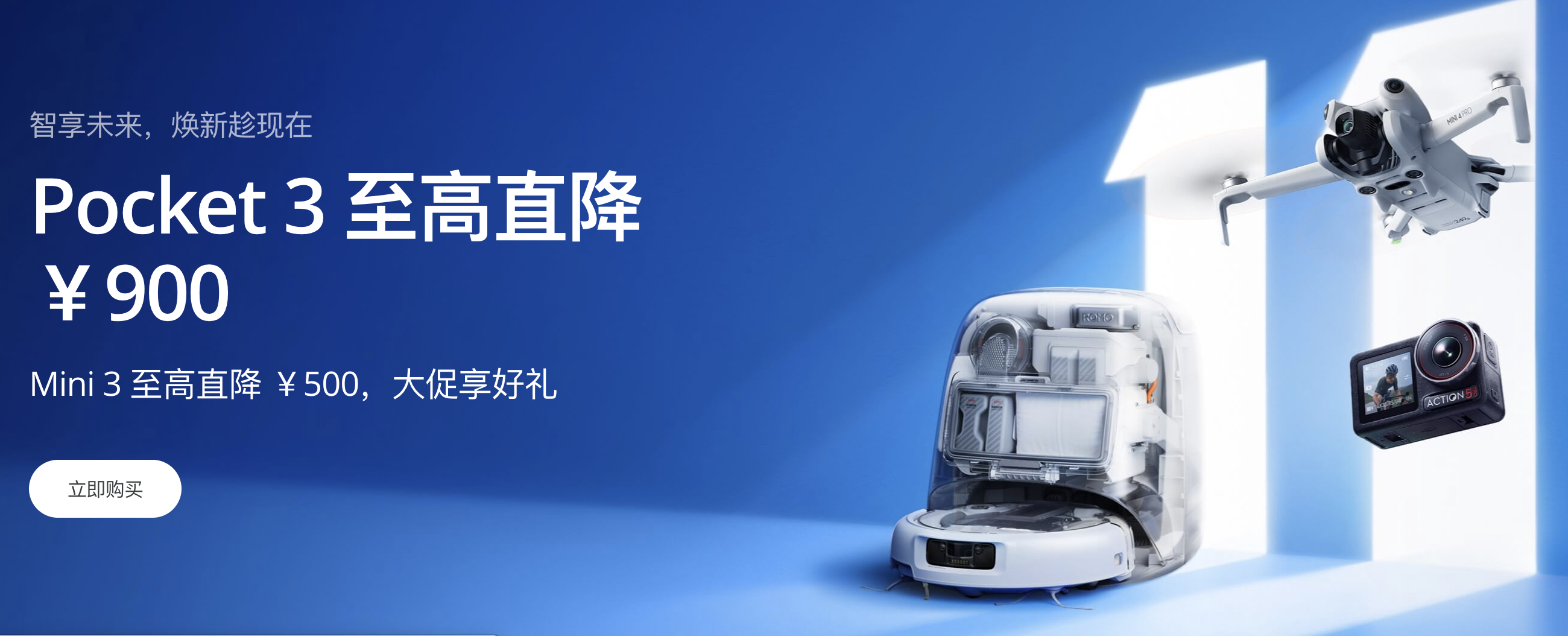
日前,大疆宣布将在 10 月 9 日正式开启双十一狂欢,多款热门产品降价:
- 手持云台相机 Pocket 3 最高直降 900 元,标准版售价来到 2799 元;
- 运动相机 Action 4 最高直降 949.8 元,标准套装价格来到 1248.65 元;
- 无人机 DJI Mini 3 直降 500 元,起售价来到 2088 元;DJI Mini 4K 直降 700 元,售价来到 1499 元;
- 稳定器 DJI Osmo Mobile 系列最高直降 200 元,其中 SE 机型只需 299 元。
而在昨日,「大疆预告降价已购买消费者退货维权」冲上微博热搜,不少刚刚购买了大疆即将降价产品的消费者开始在购物平台、社交媒体上维权,争取退差价。
据第一财经、红星新闻报道,在小红书等社交媒体上检索「大疆」,可发现许多刚刚购买了大疆的消费者正在进行维权,线上、线下沟通退差价或者退货退款。许多成功退货的消费者还在笔记中分享了自己的维权经验。
据红星新闻称,多次致电大疆官方客服,均被告知「很抱歉,当前咨询客服比较多。」
而后,记者以消费者身份与大疆线上客服咨询「线下购买如何价保」时,在线客服回复称:「因不同渠道的销售模式不同,我们无法直接为您处理价保需求,需要您联系对应门店的销售人员,这样可以更快捷地为您提供相应方案。」
Cursor 创始人:AI 编程处于漫长复杂的「中间阶段」
9 月,AI 编程平台 Cursor 的联合创始人兼 CEO Michael Truell 接受了 Y Combinator 的一次深度访谈,其在节目中分享了 Cursor 的部分发展之路以及个人对行业的见解。
在正式创立 Cursor 之前,Truell 的团队经历了数次代价高昂的失败,如耗时六个月,为机械工程师打造 CAD 领域的「Copilot」,以及端到端加密通信系统,但最终都因缺乏领域热情、用户反馈寥寥而宣告失败。
「那种『无奈感』反而帮助我们明晰了自己真正关心和追求的方向,」Truell 坦言。正是这些失败,让团队意识到他们内心真正的热情在于「编码的未来」。
当时的他们坚信,「在未来五年里,整个编码领域都有可能发生改变,所有软件开发都可能通过模型来完成」,而现有玩家并未全力朝这个方向迈进。
对于 AI 将如何重塑编程,Truell 认为行业正处在一个漫长而复杂的「中间阶段」。「AI 会越来越像你的同事,或者一个非常高级的编译器,但你仍然需要阅读逻辑、进行审查和编辑。」
对话中,Truell 还向年轻一代的开发者和创业者给出了自己的建议:
我觉得最重要的是去做你真正感兴趣的事情,并且和那些你既喜欢相处又非常尊重的人一起去做,而且要非常认真地对待。避免为了完成任务而去「打勾」,应专注于能够长期积累、真正构建你感兴趣的东西。
消息称 M5 iPad Pro 或即将推出
日前,记者 Mark Gurman 发文称,iPad Pro M4 在苹果零售店及线上渠道的供应数量有限,部分配置甚至出现延迟,而这也是苹果一个即将推出 M5 iPad Pro 的明确迹象。
Gurman 还称,入门级的 14 英寸 MacBook Pro 也出现上了上述情况,而搭载 M4 Pro/Max 的机型(14/16 英寸 MacBook Pro)则未出现库存紧张的情况。
据此前消息曝光,M5 iPad Pro 计划作为 M5 的首发机型登场;除了处理器提升,苹果还可能会在正面加入一枚用于自拍的镜头(类似以前放在屏幕短边侧的前置摄像头)。
10 月 2 日,Gurman 还发文透露,苹果暂停了对 Vision Pro 的全面升级计划,同时将资源分配到了智能眼镜项目上,以此对抗 Meta 的 AI 眼镜强势的冲击。
具体来看,原计划更轻便、更便宜、2027 年发布的「N100」头显项目已被苹果喊停,而该项目的人员已转移至智能眼镜的研发。
报道称,苹果目前正在准备两款智能眼镜产品:一款代号为「N50」的无屏智能眼镜,计划明年推出;而对标 Meta Ray-Ban Display 的带屏眼镜,原计划 2028 年发布,苹果则正在寻求加快开发进度。
另据 MacRumors 报道,iPad mini 8 也已经在来的路上。
新款 iPad mini 屏幕尺寸将加大,从原先的 8.3 英寸增大至 8.7 英寸,并且采用 OLED 显示技术;处理器方面则采用 iPhone Air 同款 A19 Pro。
真我 GT8 Pro 将与理光合作
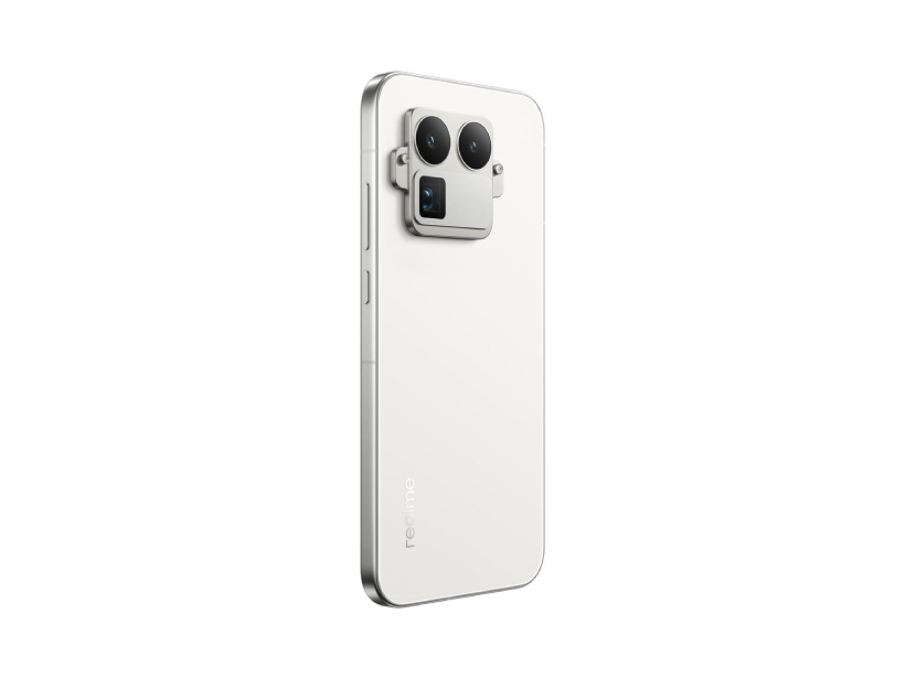
刚刚,真我正式宣布,将与理光映像达成影像战略合作,而即将发布的真我 GT8 Pro 也有望成为双方合作的首款产品。
据悉,真我 GT8 Pro 将采用拼装式后置镜头模组设计。从透露的信息来看,新机将采用后置三摄系统,拥有潜望式长焦。
据数码闲聊站与徐起透露,真我 GT8 Pro 将采用 50MP 1/1.56 英寸大底主摄以及 2 亿长焦,同时超广角也会升级。
其他方面,真我 GT8 Pro 将采用 2K 直屏,支持全亮度类 DC 调光 + 圆偏振光护眼;搭载骁龙 8 Elite Gen 5 和苍穹信号芯片 S1,支持 21 个 5G 频段(含 n79);配备两枚 1115E 扬声器,支持无线充电。
新机预计 10 月发布。
索尼 α7 V 被曝或 11 月发布
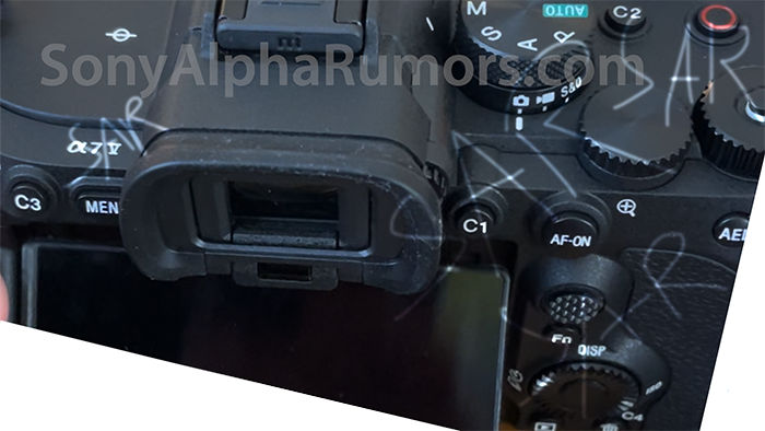
日前,Sony Alpha Rumors 发文透露,索尼有望在今年 11 月公布旗下最新全画幅无反相机 α7 V(ILCE-7M5),并且或会在明年 1、2 月正式发货。
据透露,α7 V 将配备一块 3300 万像素的全幅传感器,暂未确定是否为 α7 IV(ILCE-7M4)的升级版传感器。值得一提的是,新机将搭载类似 α1 II 上的 AI 芯片。
机身方面,新机将采用 α7rV(ILCE-7RM5)相同的机身设计,拥有四向翻转屏以及一致的操控按钮布局。
价格方面,α7 V 售价或为 3000 美元,约合人民币 21358 元。
微信灰测「批量撤回消息」功能
据快科技报道,近期有网友发文称微信推出批量撤回消息功能。
据了解,当用户在微信聊天框中长按两分钟内发送的消息并点击「撤回」时,会出现两个选项:「撤回该条消息」和「撤回本次发送的全部消息」。
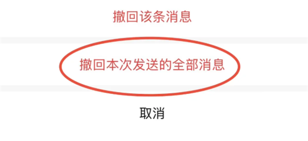
选择「撤回本次发送的全部消息」即可一次性撤回本次发送的所有消息(包括文字、图片、语音等),无需逐条操作,再也不怕发错消息时手忙脚乱却撤不完的情况。
需要注意的是,该功能还在灰度测试阶段,只有部分用户可以使用。
据悉,微信常规消息可在 2 分钟内撤回,如文字、语音、表情包、图片等。其中,文字消息撤回后 5 分钟内可重新编辑,无需重新输入;文件内容则支持 3 小时撤回,如 Word、Excel、PPT 等。
所有消息撤回之后,对方都会看到相关提醒,提示对方撤回一条消息。
对于为何撤回之后要提醒对方,腾讯曾表示,如果在一些商务谈判或借贷等特定场合,撤回信息无文字提示,可能会导致一方出现利益受损的情况。
2025「国庆中秋」假期数据报告公布
昨日,微信派公布了《2025 微信国庆中秋数据报告》。
报告显示,新一线城市与县域市场潜力大:消费总额对比五一假期增幅达到了 10%。其中重庆消费金额成为消费金额、笔数双「全国第一」(除北上广深)。
而热门消费行业中,运动健身消费笔数同比增长 16%;美容美发金额和数码产品消费金额均同比增长 11%。
据央视新闻报道,2025 年 10 月 1 日—8 日,累计全社会跨区域人员流动量预计 24.32 亿人次,日均 3.04 亿人次,同比(2024 年国庆假期 7 天日均,下同)增长 6.2%。其中:
- 累计铁路客运量预计 1.53 亿人次,日均 1924 万人次,同比增长 2.6%;
- 累计公路人员流动量预计(包括高速公路及普通国省道非营业性小客车人员出行量、公路营业性客运量)22.47 亿人次,日均 2.80 亿人次,同比增长 6.5%。
- 其中,累计公路营业性客运量预计 3.06 亿人次,日均 3833 万人次,同比增长 2.9%;累计高速公路及普通国省道非营业性小客车人员出行量预计 19.40 亿人次,日均 2.42 亿人次,同比增长 7.1%。
- 累计水路客运量预计 1167 万人次,日均 146 万人次,同比增长 4.2%。
- 累计民航客运量预计 1917 万人次,日均 240 万人次,同比增长 3.4%。
华为工程人员回应「鸿蒙 5 App 不适配」:有些群体别升级
据新浪财经报道,近日,有自称华为老粉的博主王晓东在社交媒体吐槽华为鸿蒙 5.1 系统,称自己从鸿蒙 4.3 升级至鸿蒙 5.1 后遭遇微信、抖音等主流应用无法「完全兼容适配」,部分功能无法正常使用。
其还表示,在亲自跑到华为售后门店「刷机」回退此前版本后,却也浪费了大量时间,且遭遇「部分数据丢失」。相关内容被大量转发并引发消费者共鸣,大量用户自称被鸿蒙 5 系统「逼疯了」「坑死了」。
对此,华为消费者热线工程人员回应并透露,由于鸿蒙 5 操作系统全面自研,不再基于安卓系统开发,这导致其上的各类应用均需进行重新设计开发。
工程人员表示,虽然,目前大部分软件「已上线 80% 的功能」,但仍有部分功能还在开发适配中,视频创作者等群体「暂不建议升级至鸿蒙 5.1」。
今年 7 月,鸿蒙 5 终端数突破 1000 万。据华为常务董事、终端 BG 董事长余承东国庆前夕透露,目前鸿蒙 5 终端设备已突破 2000 万。快速的设备数攀升,意味着鸿蒙 5 已经进入加速成长的新阶段。
8 月中旬,余承东在谈及鸿蒙操作系统的发展时,曾将移动操作系统和生态的建设,视为这是「先有鸡还是先有蛋」的哲学思辨。
在他看来,操作系统刚发布,很多应用还没有做出来,用户能不能承受得了是一个问题。但如果等系统成熟了再发布,没有用户基础,大家也不愿意开发应用。
《三角洲行动》发文回应「撤离点人数限制」争议
日前,《三角洲行动》发布烽火地带平衡性更新,宣布部分撤离点增加超载机制,深蓝再次削弱。而此次调整在网上引起玩家热议。
昨日,《三角洲行动》官方发布致歉公告,承认近期更新引发大规模玩家不满,并宣布优化及补偿措施。官方表示,团队看到了许多意见与批评,也深刻意识到处理方式的突兀与不妥。
回应中,《三角洲行动》官方解释了相关调整争议:
- 针对「共享监狱」现象做出紧急调整:官方发现潮汐监狱开始出现三盾或双盾组合,跨队伍联合对抗其他队伍,影响了对局体验,并快速演变成全图拉闸直接撤离的现象。随着「共享监狱」快速扩散,随后而来的可能将是快速「刷物资」导致装备物价持续飞涨、大红大金变成「白菜价」,进而影响其他地图和更大盘的游戏体验
- 撤离点人数限制:当前的方案是官方发现数据异常并逐步影响全盘后,紧急做出的决策。针对为什么限制,官方表示「尽可能不影响混闸撤离的前提下,减少上述情况发生。」
目前,游戏团队也正在评估更优方案来改善「共享监狱」现象,以保障大盘经济及对局的稳定性,并将持续灰度测试及优化。10 月 9 日起,航天基地、巴克什两张地图的撤离 5 人限制将逐步解除。
另外,游戏官方还针对「长鳄奔月」相关内容进行说明:
7 月时,我们脑洞了一个「长鳄奔月」的中秋谐音梗,并准备了中秋活动和趣味视频。但由于当前事件,我们暂停了视频发布。游戏内活动的文案是在 9 月 17 日版本更新前就合入游戏的内容,并非临时加入,不存在、也绝对不敢有任何影射和内涵的行为,十分抱歉让大家误会了。
2025 国庆档总票房破 18 亿
据灯塔专业版消息,截至 10 月 8 日 15 时 44 分,2025 年国庆档(10 月 1 日—10 月 8 日)档期总票房突破 18 亿,具体来看:
- 《志愿军:浴血和平》以 4.42 亿的档期票房获得 24.6% 的占比;《731》则以 3.4 亿的档期票房获 18.9% 占比;
- 《刺杀小说家 2》以 2.9 亿的档期票房排名第三,占比 16.1%;
- 《浪浪人生》《震耳欲聋》《三国的星空第一部》《风林火山》《毕正明的证明》《猪猪侠·一只猪的逆袭》进入排行榜前九。
霉霉新专电影票房破 4600 万美元

据新浪电影报道,巨星歌手泰勒·斯威夫特(Taylor Swift)的新专辑电影项目《The Official Release Party of a Showgirl》北美上映首周/三天票房粗报 3300 万美元,夺下这个星期的北美周榜冠军。
影片的全球首周票房方面获 4600 万美元,CinemaScore 观众评分为少见的 A+。
该影片为一部「非传统电影」,89 分钟内容包括新专辑《The Life of a Showgirl》中的新歌 MV、专辑制作幕后画面等。值得一提的是,该片仅在 10 月 3 日至 5 日上映。
电影《不东》宣布杀青

据新浪电影消息,跑步题材电影《不东》日前在甘肃瓜州戈壁圆满杀青。
电影讲述一群跑者以脚步丈量生命,为梦想「跑」出黎明的故事,致敬每一个在人生路上跌跌撞撞却未曾停下的人。
该片由吴飞跃、秦晓宇执导,邓家佳领衔主演,谷嘉诚、汤加文、鞠帛展、刘贾玺、Hamza、蔡少天、康轩、吕晓霖、刘禹泽主演,张国强特邀出演。
#欢迎关注爱范儿官方微信公众号:爱范儿(微信号:ifanr),更多精彩内容第一时间为您奉上。
爱范儿 |
原文链接 ·
查看评论 ·
新浪微博


_(cropped).jpg)
.png)
.jpg)
.jpg)
,_mar_Rojo,_Egipto,_2023-04-19,_DD_47.jpg)